Texas Storms Dropped Massive Hail and Flooded Roads — Then Drivers Still Had to Be Told Not to Risk It
South Texas got another reminder this week that a storm does not have to last all day to make a mess.
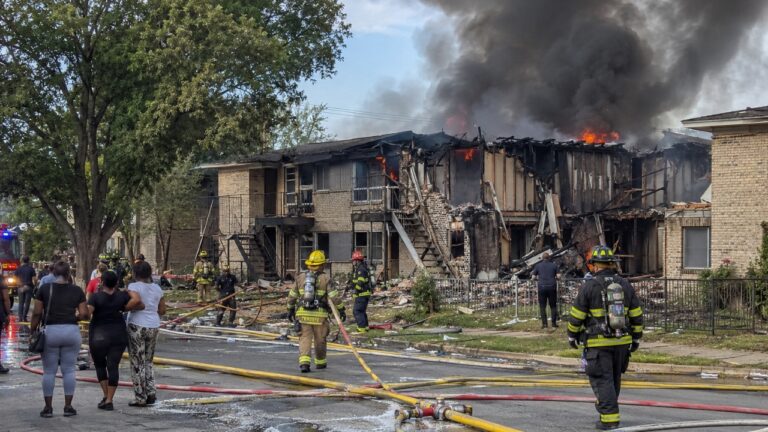
Severe weather pushed through the region Tuesday night, bringing heavy rain, tornado warnings, flooding, and hail big enough to make people stop and take pictures. By Wednesday morning, some communities were still dealing with high water, stranded drivers, and the familiar warning Texas officials repeat every storm season.
Do not drive through flooded roads.
According to MySA, Atascosa County saw serious flooding after the storms, especially around Charlotte, where water was still covering roads the next day. The Atascosa County Sheriff’s Office warned residents not to try crossing flooded areas, reminding drivers that fast-moving water can be stronger than it looks.
That warning may sound routine, but it is one of the most important messages during Texas flash flooding.
A road can look passable from a distance. The water may not appear very deep. But once a vehicle enters it, the driver may find out too late that the road is washed out, the current is moving faster than expected, or the tires no longer have enough grip to stay put.
That is how a bad decision turns into a rescue.
MySA reported that the Texas Division of Emergency Management assisted with rescues across Central Texas as storms moved through. In parts of Atascosa County, rainfall totals topped five inches. That much water falling quickly can overwhelm low-water crossings, ditches, rural roads, and drainage systems.
And flooding was only one part of the storm.
People also reported large, unusual hail. Photos shared from Stonewall showed hailstones with jagged, spiky edges, the kind that look less like smooth ice pellets and more like something that could tear into a roof, dent a vehicle, or shatter a windshield.
Anyone who has lived in Texas long enough knows hail can be one of the most expensive parts of a spring storm. It may only fall for a few minutes, but those few minutes can leave behind damaged cars, broken windows, battered siding, and nervous homeowners calling insurance companies the next morning.
The same storm system also triggered several tornado warnings.
The National Weather Service issued warnings for areas northeast of San Antonio, including Schertz, Universal City, Converse, Seguin, Belmont, and parts of Atascosa and Guadalupe counties. The warnings came as strong storms moved through the region Tuesday night, bringing the kind of weather that sends people checking radar, grabbing flashlights, and deciding which room in the house is safest.
One confirmed tornado did touch down near Santa Clara in Guadalupe County. The San Antonio Express-News reported that the tornado was rated EF1, with estimated peak winds of 105 mph. It was on the ground for about five minutes and traveled just under three miles before lifting.
That may sound brief, but five minutes is more than enough time for serious damage.
The worst damage from that tornado was reported near Kunde Road, where trees were heavily damaged. The same storm system also brought damaging straight-line winds in parts of the San Antonio area, even where tornadoes were not confirmed.
For residents, the difference between tornado damage and straight-line wind damage may matter to meteorologists and insurance adjusters later. In the moment, it all feels dangerous.
The wind is loud. The rain is sideways. Phones are buzzing with alerts. Roads are flooding. Hail is hitting roofs. Nobody knows exactly which part of the storm will cause the biggest problem until it is over.
By Wednesday, the region was left sorting through the aftermath.
Some areas had standing water. Others were looking at hail damage. In Guadalupe County, crews had to assess the tornado path. In Atascosa County, officials were still warning people about flooded roads.
The strange thing about Texas weather is how quickly it can shift from ordinary to serious.
A hot, humid evening can turn into tornado warnings. A rural road can become a water crossing. A thunderstorm can drop hail that looks like it belongs in a disaster movie. Then, just a few hours later, the sun may come out and people have to figure out what got damaged.
This week’s storms were another example of that whiplash.
They brought the drama Texans know too well: hail, flooding, wind, warnings, and the constant risk that someone will try to drive through water they should have avoided.
Thankfully, early reports focused more on rescues and property damage than widespread injuries. But the storm still carried a clear message.
In Texas, the dangerous part of a storm is not always the lightning or the tornado warning.
Sometimes it is the flooded road that looks harmless until it is not.

Arlie Howard contributes coverage on consumer issues, family-focused stories, household concerns, scams, local cost-of-living topics, and real-life situations that affect Texas readers.
Her work focuses on explaining what happened clearly and helping readers understand the details that may matter most.