Strange Clouds Appeared to Trace Houston’s Freeways From Space
Houston traffic has been blamed for plenty of things over the years.
Long commutes. Construction headaches. Endless brake lights. A daily test of patience on the Katy Freeway.
But this week, Houston’s road system appeared to do something even stranger.
It seemed to help draw clouds.
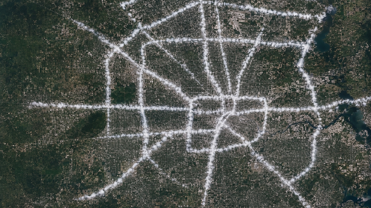
Satellite images from Tuesday morning showed narrow lines of clouds forming over parts of the Houston freeway system, creating a pattern that looked surprisingly similar to the city’s road grid. According to the Houston Chronicle, meteorologists believe the unusual formation may have been connected to Houston’s urban heat island effect.
That is a fancy way of saying the city’s concrete, pavement, buildings, and traffic can hold and release heat differently than surrounding areas.
And in this case, the freeways may have stood out.
The image gained attention after storm chaser Ethan Mok shared satellite imagery from Tuesday morning, showing clouds that appeared to line up over major Houston roads. Chron reported that Space City Weather meteorologist Eric Berger noticed the striking pattern and described it as a possible microclimate effect tied to Houston’s interstates, including the Katy Freeway.
For anyone who has driven the Katy Freeway during rush hour, the idea that it has its own atmosphere may not sound completely impossible.
The Katy Freeway is famously wide in places, and Houston’s freeway network cuts through the region with enormous stretches of pavement. On a hot, humid morning, all that concrete can warm the air just above it. When warm air rises into humid conditions, it can help clouds form if the atmosphere is ready for it.
That does not mean the freeway magically created clouds out of nowhere.
The weather conditions still had to be right. Moisture had to be available. The air had to be unstable enough for cloud formation. The sky also had to be clear enough for satellite imagery to capture the pattern. But meteorologists say the pavement and city heat may have provided just enough extra lift in certain spots.
In plain English, Houston may have been warm and humid enough that its roads helped nudge clouds into forming directly above them.
The National Weather Service has long explained that cities can be warmer than nearby rural areas because buildings, roads, and pavement absorb and retain heat. The agency’s information on urban heat islands is available here: National Weather Service: Urban Heat Islands
Houston is a good place to see that kind of effect because it has the ingredients.
It is humid. It is heavily developed. It has massive roadways. It has plenty of heat. It also has a coastline nearby, which means moisture is often part of the daily weather pattern.
The surprising part was not that Houston can influence its weather. Scientists have studied urban weather effects for years. The surprising part was how clearly the pattern seemed to show up from above.
Chron reported that Berger suggested the clouds may have formed from a combination of heat released by the roadways and particles from vehicles that helped water vapor condense. Those particles can act like tiny surfaces for cloud droplets to form around.
That explanation makes the phenomenon sound less like science fiction and more like a very Houston kind of science lesson.
Traffic, heat, humidity, concrete, exhaust, and satellite imagery all met at the same time.
Researchers in Texas have also studied how cities can affect storms and rainfall. A recent Texas A&M Today report explained that Texas A&M scientists have been examining how urban areas may influence severe weather by changing heat, moisture, and airflow around cities.
That does not mean every storm over Houston is caused by the city, and it does not mean every cloud over a road is created by traffic. Weather is far more complicated than that.
But the satellite image is a reminder that cities are not just passive places where weather happens.
They can shape the air around them.
For Houstonians, the story is also a little funny because the city’s freeways are already such a big part of daily life. People plan around them. Complain about them. Measure their mornings by them. Talk about them like landmarks.
Now, for at least one morning, they appeared to leave a mark in the sky.
The clouds themselves were ordinary. The pattern was not.
And in a city where traffic already feels larger than life, Houston’s roads may have briefly become visible from space in one of the strangest ways possible.

Grady Howard contributes coverage on Texas public-interest stories, household costs, transportation, weather-related concerns, safety alerts, and consumer topics.
His reporting is built around practical context — what changed, why it matters, and what readers should pay attention to next.